Christchurch and Canterbury
Our flight arrival into Christchurch was a little too late in the day to pick up our campervan we’d booked so we stayed the night in a little cabin at a camp site near the airport. We collected the van the next day and parked up in another camp site in the city. A friendly but bored British guy who’d lived in Christchurch for a while took us for a little tour in his banger and showed us places where the city had been worst hit by the two recent severe earthquakes. Small earthquakes are very common in the area as it lies within eye-shot of a fault line.
The heart of the city is still mostly closed off while demolition and reconstruction continues, but a couple of the most interesting accessible areas included the cathedral which had been ruined and the REstart mall: a temporary shopping centre with trendy boutique shops set up in a maze of brightly coloured shipping containers! REstart mall has become such an iconic part of the city that some of the locals are petitioning to keep the containers after reconstruction of the town.
From Christchurch we decided to drive around the adjacent peninsula, visiting amazing countryside and some of the small coastal settlements and heading south towards Geraldine. We found that the Department of Conservation had many basic and cheap campsites dotted everywhere around the country which served as the perfect place to camp. We stayed at our first DOC site in the middle of nowhere on the way to Geraldine.
Driving inland from Geraldine we set off towards a couple of NZ’s famous lakes and mountains; Lake Tekapo, Lake Pukaki and Mount Cook – the highest peak in the country. With perfect sun shine highlighting the beauty of this area, we did a few of the walks to some of the best viewpoints of the mountains, lakes and Tasman Glacier.
Otago & Dunedin
After making the most of the sunshine with lots of walking, we traveled on South towards the town of Omarama and camped another night on a DOC site on the side of the road. Heading slightly away from the main tourist route we passed through the small town of Oamaru on the way to the coast. There was not much going on here but Steve got his head shaved, we tasted some local cheeses at a cheese factory and we visited a small penguin colony before we carried on to Dunedin.
Dunedin is a student town with lots happening after hours. We went for a curry and a few drinks and checked out the buzzing octagonal town centre, whilst dodging the locals that were cruising round town with their music blaring!
 |
| The strange landscape of the the Elephant Rocks on the way to Oamaru |
 |
| A nice nap on one of the Elephant Rocks |
 |
| A giant chopper in the centre of Oamaru |
 |
| Some cheese wheels in the stinky Oamaru cheese factory |
 |
| The strange Marble Rocks on the East coast |
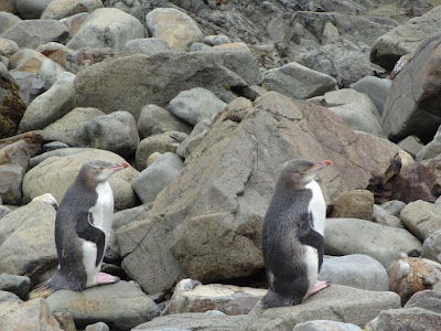 |
| Wild penguin colanies on the coast |
 |
| Jacks Blowhole - a strange hole in the ground connecting to the sea 200m away |
 |
| 3 million people vs 60 million sheep! |
Fiordland
Between the towns of Dunedin and Invercargill lies the Catlins National Park. We stayed at a DOC site in the Catlins and planned to do a nearby river walk but it became too rainy to do the river walk so we drove on through the Catlins to Invercargill. Here we stocked up on fuel and food and then cracked on to Te Anau – the hub town to Milford Sound, one of NZ’s major tourist attractions.
We arranged a guided kayaking trip on Milford Sound based on numerous recommendations and it paid off - it was stunning, definitely the best way to see the Sound! The trip took us by motor boat through the Sound and to the sea at the end of the spectacular fjord carved out by ages of glacial activity. Rainwater waterfalls cascade down the steep sided mountain cliffs into the sea, the tallest of which sticks up about a mile above the water; a spectacular setting!
On returning from our kayaking trip we found out that the only road in and out of Milford Sound had been closed just a few hours after we drove in due to a rock fall near a tunnel through one of the mountains. Luckily we weren’t delayed and we made it back out after rushing to join an escorted convoy of vehicles through the rockfall area the morning after. We took a nice walk up to Lake Marian on the Te Anau side of the tunnel on the Milford road. From there we made the 3 hour drive round to Queenstown which, although it is only around 70km directly from Milford Sound, the road actually covers more than 4 times that distance round the mountains!
 |
| A stunning reflection over a perfectly still canal on the way to Milford |
 |
| The wagon parked up in a scenic spot for the evening |
 |
| A light aircraft ready for take off in Te Anau |
 |
| Mountains reflecting on water ... camera's full of these pictures! |
 |
| Cooking up a feast in the van |
 |
| The boat out to the edge of Milford Sound before kayaking back |
 |
| Amazing fjord scenery whizzing past |
 |
| Fancy dress was part of the deal for the kayak tour! |
 |
| Kayak's eye view |
 |
| Some kayak sailing down the fjord |
 |
| Putting in all the work (just for a photo!) |
 |
| A quick snap of Milford Sound from the shore before the sandflies attacked! |
 |
| Farm animals ruling the road! Steve sent them skitz whilst they were running towards us by accidentally flashing the lights instead of washing the windscreen! Oops, wrong stork! |
Queenstown
Queenstown is the home of all adrenaline activities you can think of, all of which cost much more than our increasingly tight budget would allow! Instead of bungee jumping or skydiving we took a walk around the town and parks and up to the top of Bob's Peak overlooking Queenstown and the Remarkables followed by an amusing night out in Queenstown in a couple of cool bars. On our way out of Queenstown we took a look at the original bungee location just outside of the town on a bridge over the Kawarau River before heading on to the North.
West Coast
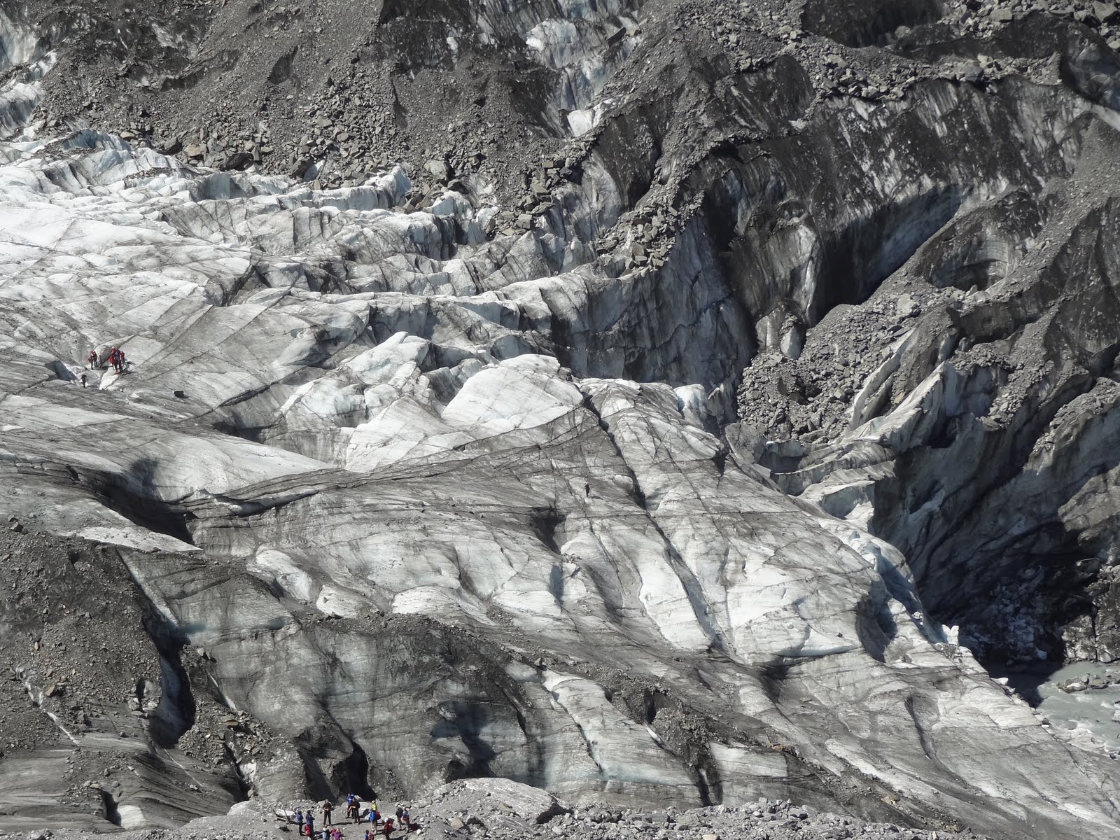
On arrival at Fox Glacier we booked ourselves onto the next available tour onto the glacier itself. This left us a little time to explore around Franz Josef Glacier and township 25km further up the coast before heading back down to Fox glacier for our much awaited trip. We stayed at another secluded DOC site at Gillespie Beach a short distance outside Fox Glacier and took in an amazing sunset the night before our glacier walk which involved a trek to the start of the glacier before donning our crampons and exploring the ice!
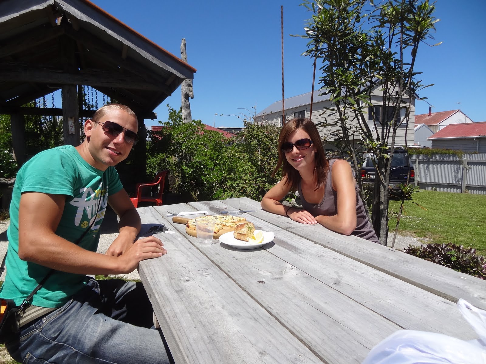
After our trip we drove back North through Franz Josef and on towards Hokitika further up the West coast. There we sampled some of the local speciality, whitebait pizza, from Fat Pipi’s Pizza and then took a side trip out to Hokitika Gorge – an unimaginably blue river passing through a stunning gorge. The vicious sand flies meant that we didn’t stick around too long though!
On our way North up the West coast of the South Island, we took a detour along Arthurs Pass; an incredible road that runs from close to Greymouth across the South Island to Christchurch over the Southern Alps. From Arthurs Pass village we did a couple of walks including the Devil’s Punchbowl Falls and Bealey Spur Hut.
From Arthur’s Pass, we stopped off at the impressive Pancake Rocks and blowholes at Punakaiki before a long drive up to Marlborough Sounds via Nelson. In the Marlborough Sounds we walked a section of the Queen Charlotte Track between Mistletoe Bay and Torea Bay which gave us amazing views along the Sounds.
After a long day’s walking in the Sounds, Steve got the van stuck at a camp site that evening on a skiddy incline sloping down to a ditch at the bottom! The darker it got and the further down the slope we skidded in our attempts to get the van out, we soon realised we were getting nowhere. We wedged the wheels so as not to slip further down the slope and slept on the slant that night - needless to say we didn't sleep that great and we were just a little concerned about how we might get the van out in time to catch our ferry to the North island the next day! With a team effort from some other sympathetic people on the camp site we managed to push the van out in the morning and luckily made it in time to Picton for our ferry crossing.
 |
| Pancake Rocks up the west coast road |
 |
| Animal forms in the pancake rock! |
 |
| Hunting for glow worms at the campsite in Marlborough Sounds! |
 |
| The spectacular Marlborough Sounds from the Queen Charlotte track |
 |
| Another Sound snap along the track |
 |
| Picton harbour in the sunshine before our trip up to the north island |
 |
| Bye bye south island! |
Wellington
Windy Wellington, as its known, was pretty breezy! We wandered round the town to the Te Papa museum full of interested exhibitions on the country and its fault line and culture. The premiere for The Hobbit was due to take place in the centre a couple of days later and was causing a stir. We went along to the cinema and watched James Bond to get us into the spirit! Kind of.
 |
| We got tricked into taking part in some clever Coca Cola advertising! |
 |
| Needed a snap of this of course! |
 |
| Gearing up for the Hobbit premier at one of the smart Wellington Cinemas |
Tongoriro National Park and Taupo
From Wellington, we drove north up to Tongoriro National Park. On our arrival the Tongoriro crossing, a famous day hike passing between Tongoriro and Ngauruhue volcanoes, was closed due to part of Mt Tongoriro erupting the week before. Whilst waiting a day for the crossing to reopen we did an alternative walk to the stunning Tama Lakes before completing the safe half of the crossing which they reopened the following day. For the Tongoriro crossing we did a return walk from Mangetipopo to Emerald Lakes and a side walk up Mt Tongoriro. During the walk we were able to see the vent still smoking away following the eruption from the week before!
The town of Taupo a short distance to the north sits next to the huge volcanic crater of Lake Taupo. With the abundant thermal activity going on, we went and looked at some steamy craters, hot streams, geysers and smelly sulphur lakes.
 |
| The awesome Volcano-scape from the road |
 |
| Hard not to get involved with some volcano-inspired mash in the van! |
 |
| Perfectly cone shaped Mount Ngauruhoe as the cloud sinks below it - aka Mount Doom in Lord of the Rings |
 |
| Every bit as dramatic in the day light |
 |
| From the top of our climb to the Tama Lakes |
 |
| Over one of the Tama Lake towards Ruapehu - the biggest of the Volcanoes in Tongoriro National Park |
 |
| The Maori blessing ceremony before the re-opening of the Tongoriro Crossing after it erupted a week before we arrived |
 |
| At the start of the amazing Tongoriro Crossing trek |
 |
| A snap for the Christmas cards to send home! |
 |
| Mt Doom poking through the clouds from near the summit of Mt Tongoriro |
 |
| The Emerald Lake at the half way point of the Crossing |
 |
| The Red Crater area |
 |
| Mt Doom and Tongoriro |
 |
| A side vent of Mt Tongoriro still blowing smoke a week after erupting |
 |
| Another view of the Tongoriro vent still having a hissy fit after its eruption |
Bay of Plenty and Coromandel
On our way North up to Auckland, we stopped off at Rotorua, a small town with plenty more thermal activity and Maori culture. We also stopped off at the local seaside destination of Tauranga and climbed to it's viewpoint at the top of Mt Maungarui, then headed to the infamous 'Hot Water Beach' near Coromandel and Thames.
 |
| Lake Taupo - created by a huge supervolcanic eruption 25,000 year ago! |
 |
| The 'craters of the moon' thermal field near Taupo |
 |
| The awesome power of the Huka Falls near Taupo - 220,000 litres per second! |
 |
| HOT water stream near Taupo - a natural thermal spring |
 |
| A Maori carving shrouded by thermal steam on the way out of Taupo |
 |
| Geothermal power generation |
 |
| The geyser being set off with soap powder at the Wai O Tapu thermal park |
 |
| The champagne lake at Wai O Tapu |
 |
| A green lake full of sulphur at Wai O Tapu |
 |
| A fan tail - speedy little native NZ bird |
 |
| A bit of levitation in the steaming Champagne pool at Wai O Tapu |
 |
| Amazing colours and surreal steamy surface of the Champagne Pool |
 |
| Hot mud flicking from mud springs - Caroline found out just how hot it was when it splattered on her leg! |
 |
| A typical Maori building in the centre of Roturua |
 |
| The local church in Roturua with most of the town's population inside for a wedding! |
 |
| The picturesque Art and History Museum in Roturua |
 |
| A nice spot to camp and enjoy sunset from the van |
 |
| From the summit of Mt Maunganui overlooking Tauranga |
 |
| Stingray Bay on the Coramandel Peninsula |
 |
| Cathedral Cove |
 |
| Digging for hot water at Hot Water Beach - at first we thought it was a big practical joke but we soon found the thermal water running through at about 65 degrees! |
 |
| Sharing our freshly dug hot bath with some new friends! |
 |
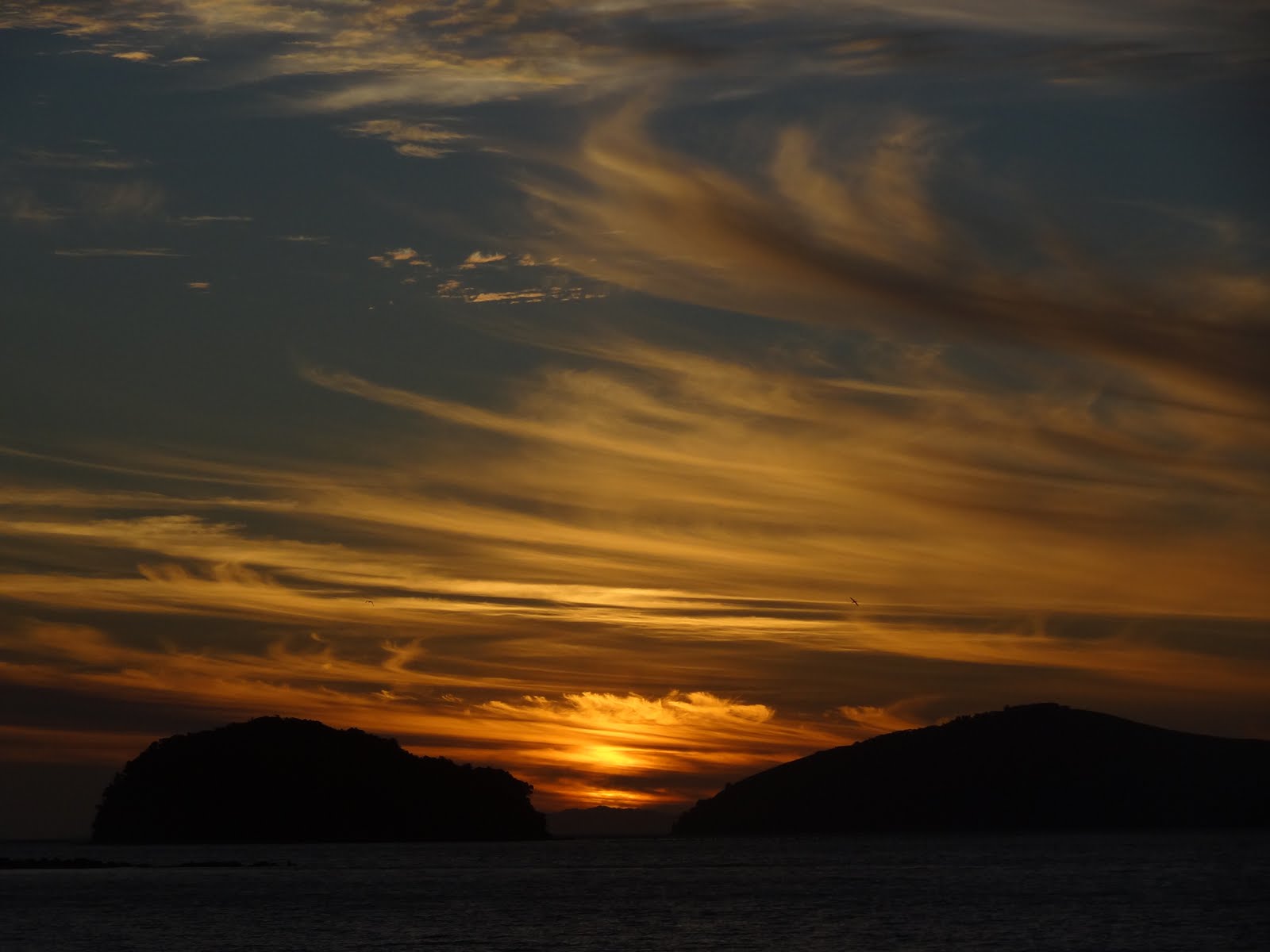
| An amazing sunset developed at our camp site at Coromandel |
Auckland and away
When we eventually got to Auckland, we met up with Michael and Priscilla who we first met in Norwich 18 month previous. As well as educating us about Aukland and NZ, Michael and Priscilla invited us in for a lovely home-cooked meal and kindly allowed us to camp on their driveway! The weather in Auckland was terrible but we explored the city on our last full day.
 |
| Rainy Auckland |
 |
| Raining quayside in central Auckland |
 |
| Auckland Sky Tower on a grey day before the tornado hit |
The next morning, we packed up our bags and cleaned up the van ready for return as the weather got more and more thundery and wet. After an issue-free return of our van, our flight out of Auckland was delayed due to a tornado which explained the bad weather over the previous few days!


Nice one :-) Loving the pictures guys!
ReplyDelete